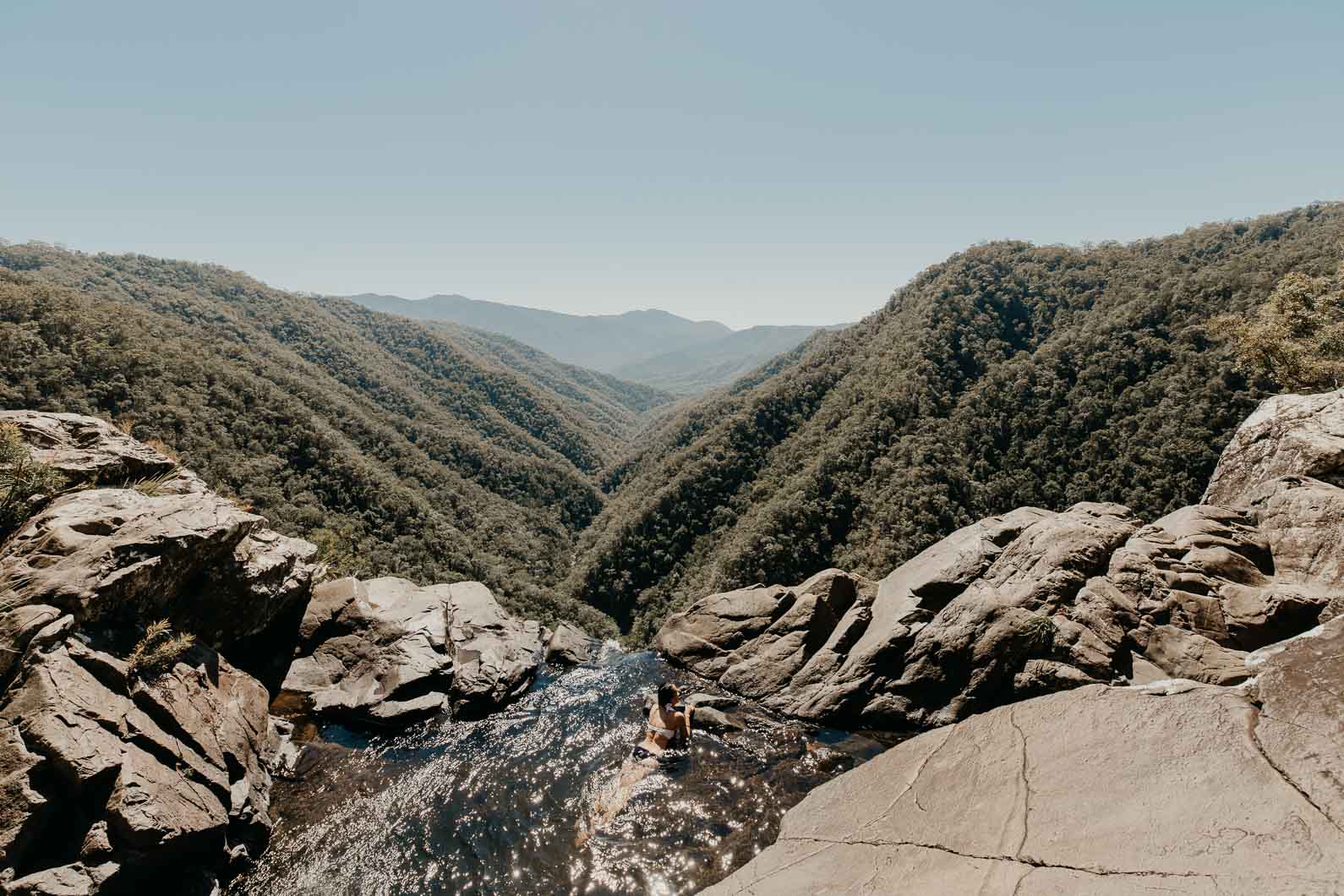
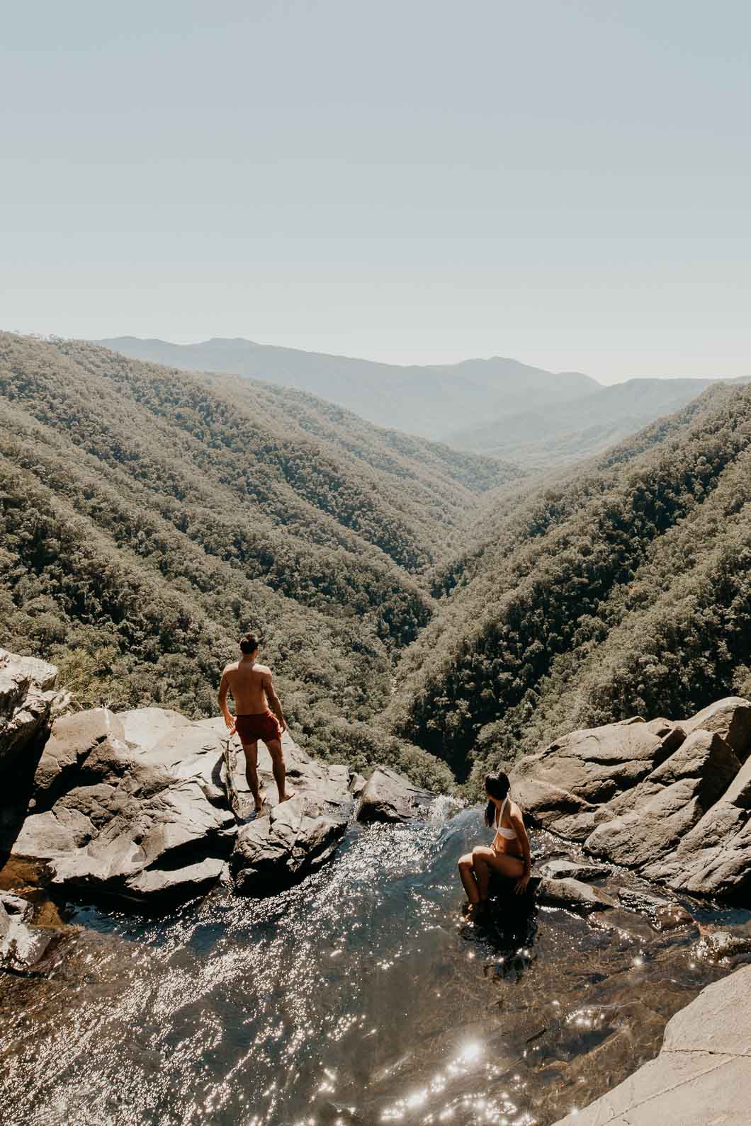
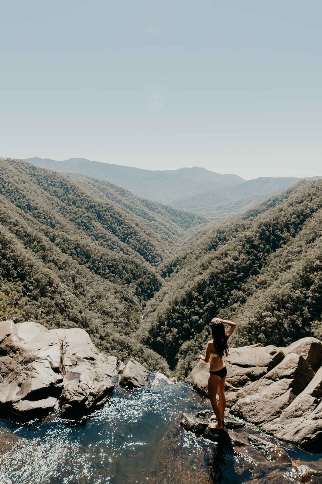
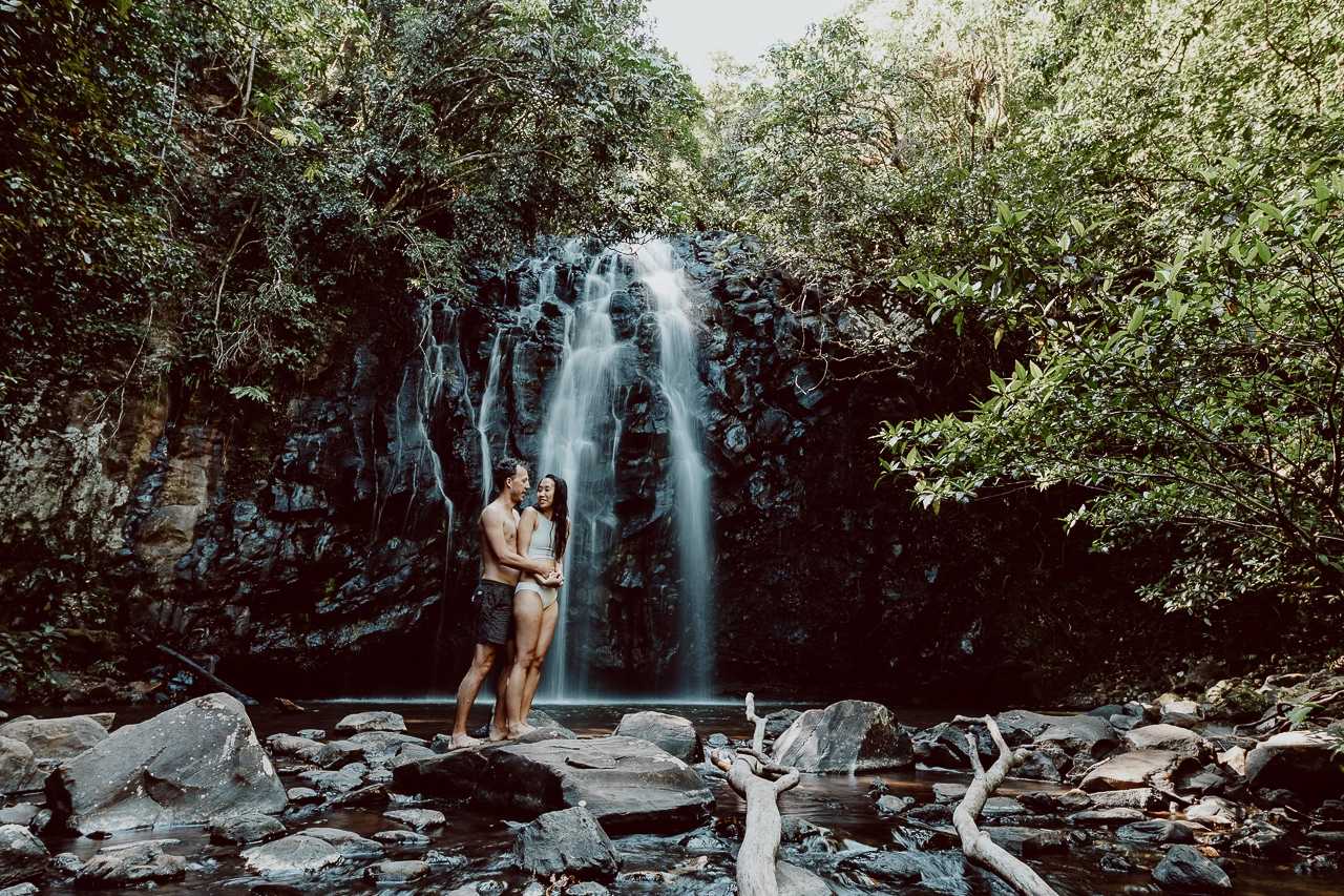
A long hike with the chance of coming face to face with a cassowary or slithering serpent is worth the trek and risk when the reward is breathtaking views from an infinity pool at the top of Windin Falls.
We ventured to this beautiful spot during October on our epic road trip in tropical north Queensland. It is hands down one of the most scenic waterfalls near Cairns and the Atherton Tablelands, with jaw dropping views over the Jurassic valley.
In this blog post, we provide information on how to get to Windin Falls including information about the Windin Falls walking track.
Share
HOW TO GET TO WINDIN FALLS FIND THE INFINITY POOL IN THE ATHERTON TABLELANDS
Windin Falls Quick Facts
Opening Times/Seasons: All day/ All year
Entrance Fee: Free
Can you swim at Windin Falls? Yes
Can you camp at Windin Falls? No
Toilets: No
Picnic tables: No
BBQ: No
Where is Windin Falls?
Windin Falls is located on the border of Wooroonooran National Park and Gadgarra National Park in The Atherton Tablelands, North Queensland. The closest town is Malanda and the nearest locality is Glen Allyn.
The great thing about Windin Falls is that you need to trek along a marked trail in order to reach the top of the falls upon which sits a natural infinity pool.
How to get to Windin Falls from Cairns?
To get to Windin Falls from Cairns, you will need your own vehicle as this location is not included as part of any tour. The drive to Windin Falls from Cairns is approximately 85kms and will take about 90 minutes. You won’t find Windin Falls on Google Maps so you’ll need to navigate using GPS coordinates.
Start by driving to Lamins Hill Lookout (which is found on Google Maps). From Cairns, follow the Bruce Highway (A1) southbound until you reach Gordonvale. Turn right and head along State Route 52 to Lake Barrine Road in Yungabarra. Continue to follow Lake Barrine Road and then Topaz Road, heading towards Lamins Hill Lookout and the start of the Old Cairns Track.
From this checkpoint, continue on Old Cairns Track for about 4.4km. Old Cairns Track goes from paved road to dirt road, however, a 4WD is not necessary to navigate this road.
There are other blog posts which refer to signposts to Windin Falls, a car park and gates to clamber over. We encountered none of these and based on our experience, our theory is that we hiked the non-official trail. We were fortunate to meet a couple who directed us to the beginning of the trail.
Where we began walking, the hike is not marked so take note of the below GPS coordinates. If you reach a sign that says Mount Bartle Frere Western trail head, you have gone too far. Search for the beginning of the trail by looking for red clay. Here, the trail is rather wide and may look inviting to drive your vehicle up this dirt track. Don’t do this, but leave your vehicle at the edge of the Old Cairns track instead. Take care not to block the road as logging trucks often use this route.
GPS: -17.349010, 145.727970 (driving)
How long is the Windin Falls hike?
There are a couple of starting points to Windin Falls. We took the slightly longer version which was a round trip of about 11.5km. Both trails require a moderate level of fitness. After heavy rainfall, the trail can become muddy and flooded.
The Windin Falls hike is relatively flat (elevation gain is ~350m, mostly on the return journey). The start of the trail begins with red clay. It is tightly packed, particularly after some rainfall. From here, you will reach a section of the trail covered in dead leaves before walking onto a section of the track littered in pine needles. Most of the trail is shady from the tree cover and it is wide enough for two people to easily walk side by side.
After about 5 kilometres, there is a steep descent to reach the top of the waterfall. Here, the trail narrows so you will need to go single file and navigate low shrubbery.
Allow yourself around 3-4 hours for the return hike, time to take photos and a swim in the infinity pool.
Safety Tips for Visiting Windin Falls From Cairns
Avoid swimming in the infinity pool after heavy rainfall
Don’t stray too close to the edge – there are no barriers here and the rocks may be slippery from recent rainfall or the gushing water
Make sure to have a full tank of petrol – the closest petrol station is a Caltex at Malanda
Wear enclosed shoes for the hike – sturdy hiking shoes are probably best but trail shoes or runners would suffice for this track
Screenshot or bookmark this blog post as there is no reception!
Keep an eye out for cassowaries and snakes – do not approach the wildlife as they will feel threatened and one or both of you could become severely injured! If you encounter any wildlife, stay calm and do not make any sudden movements. Pass them as quickly and safely as possible
Do not hike alone – Windin Falls is an isolated spot with no reception
What do I need to hike to Windin Falls?
Hiking boots | We recommend sturdy, reliable footwear for this hike. Trail shoes and runners would suffice
Basic first-aid kit | Including a space blanket
Reusable water bottles | We recommend a bottle with a filter like this Grayl water bottle
Adequate drinking water | Bring a sufficient amount for a day’s walk and then extra!
Biodegradable wet wipes | For when clean water is not available.
Hat, sunscreen, sunglasses and insect repellent
Adequate clothing for all weather conditions including rain
Swimsuit & microfibre towel if you plan on swimming
Fully charged mobile phone | Mobile phone coverage is limited. Telstra seems to work best out here but there is no reception on this trail. You’ll likely be using your mobile phone to check the instructions you have a screenshot of!
Torch or headlamp | For when nature calls in the middle of the night!